9  Geospatial Data

9.1 Introduction

  • Geographic data corresponds to data that have been linked to a geographic coordinate system

    • Point-referenced: e.g., latitude and longitude
    • Areal: polygons; grid; counties/states
  • Working with geographically located data is a relatively new phenomenon

    • It requires a significant amount of computing power and specialized programs
  • Nowadays such lack of geographic data is hard to imagine

    • Every smartphone has a global positioning (GPS) receiver and a multitude of sensors on devices ranging from satellites and semi-autonomous vehicles to citizen scientists incessantly measure every part of the world
Code
## install.packages("leaflet")
library(leaflet)

popup = c("Storrs, Connecticut")
leaflet() %>% 
  setView(lng = -72.251194, lat = 41.807417, zoom = 1)%>%
  addProviderTiles("NASAGIBS.ViirsEarthAtNight2012") %>%
    addMarkers(lng = c(-72.251194),
             lat = c(41.807417), 
             popup = popup)
Code
popup = c("SSH Building")
leaflet() %>% 
  setView(lng = -72.251194, lat = 41.807417, zoom = 12)%>%
  addTiles() %>%
  addMarkers(lng = c(-72.251194),
             lat = c(41.807417), 
             popup = popup)

There are many ways to handle geographic data in R, with dozens of packages in the area. The ones that we will focus on in this course are:

  • sp
  • sf (very functional with the tidyverse)
  • raster

Honorable mentions:

  • maptools
  • rgdal

9.2 The sp Package

The sp package provides the original infrastructure for handling spatial data in R. It defines formal S4 classes for representing geographic features—points, lines, polygons, and grids—together with their coordinate reference systems (CRS) and attribute data. These structures form the foundation for spatial analysis, visualization, and conversion between coordinate systems.

Although newer packages like sf now offer simpler data-frame-based representations, sp remains widely used and is essential for understanding many legacy R spatial workflows.

  • The first general package to provide classes and methods for spatial data types that was developed for R is called sp.
  • The package provides classes and methods to create points, lines, polygons, and grids and to operate on them.

9.2.1 Building a sp Object

Let’s build a sp object:

Code
#install.packages("sp")
library(sp)

#create the highways 
ln1 <- Line(matrix(runif(6), ncol=2))
ln1
An object of class "Line"
Slot "coords":
          [,1]      [,2]
[1,] 0.9089826 0.1298057
[2,] 0.2503783 0.4034792
[3,] 0.9638094 0.4657451
Code
ln2 <- Line(matrix(runif(6), ncol=2))
ln2
An object of class "Line"
Slot "coords":
          [,1]      [,2]
[1,] 0.4099365 0.6904562
[2,] 0.7023185 0.9883888
[3,] 0.8222399 0.9577005
Code
str(ln1)
Formal class 'Line' [package "sp"] with 1 slot
  ..@ coords: num [1:3, 1:2] 0.909 0.25 0.964 0.13 0.403 ...

Note that the @coords slot holds the coordinates

Code
## combine the highways to a Lines object
lns1 <- Lines(list(ln1), ID = c("hwy1")) 
lns2 <- Lines(list(ln2), ID = c("hwy2")) 

str(lns1)
Formal class 'Lines' [package "sp"] with 2 slots
  ..@ Lines:List of 1
  .. ..$ :Formal class 'Line' [package "sp"] with 1 slot
  .. .. .. ..@ coords: num [1:3, 1:2] 0.909 0.25 0.964 0.13 0.403 ...
  ..@ ID   : chr "hwy1"

The Line objects are now in a list and we have an additional ID slot, which uniquely identifies each Line object .

Code
# create a geospatial object with SpatialLines
sp_lns <- SpatialLines(list(lns1, lns2))

str(sp_lns)
Formal class 'SpatialLines' [package "sp"] with 3 slots
  ..@ lines      :List of 2
  .. ..$ :Formal class 'Lines' [package "sp"] with 2 slots
  .. .. .. ..@ Lines:List of 1
  .. .. .. .. ..$ :Formal class 'Line' [package "sp"] with 1 slot
  .. .. .. .. .. .. ..@ coords: num [1:3, 1:2] 0.909 0.25 0.964 0.13 0.403 ...
  .. .. .. ..@ ID   : chr "hwy1"
  .. ..$ :Formal class 'Lines' [package "sp"] with 2 slots
  .. .. .. ..@ Lines:List of 1
  .. .. .. .. ..$ :Formal class 'Line' [package "sp"] with 1 slot
  .. .. .. .. .. .. ..@ coords: num [1:3, 1:2] 0.41 0.702 0.822 0.69 0.988 ...
  .. .. .. ..@ ID   : chr "hwy2"
  ..@ bbox       : num [1:2, 1:2] 0.25 0.13 0.964 0.988
  .. ..- attr(*, "dimnames")=List of 2
  .. .. ..$ : chr [1:2] "x" "y"
  .. .. ..$ : chr [1:2] "min" "max"
  ..@ proj4string:Formal class 'CRS' [package "sp"] with 1 slot
  .. .. ..@ projargs: chr NA

A data frame can be created with a column of SpatialLines.

Code
## create a SpatialLinesDataframe
dfr <- data.frame(id = c("hwy1", "hwy2"), # note how we use the same IDs from above!
                  cars_per_hour = c(78, 22)) 

sp_lns_dfr <- SpatialLinesDataFrame(sp_lns, dfr, match.ID = "id")

str(sp_lns_dfr)
Formal class 'SpatialLinesDataFrame' [package "sp"] with 4 slots
  ..@ data       :'data.frame': 2 obs. of  2 variables:
  .. ..$ id           : chr [1:2] "hwy1" "hwy2"
  .. ..$ cars_per_hour: num [1:2] 78 22
  ..@ lines      :List of 2
  .. ..$ :Formal class 'Lines' [package "sp"] with 2 slots
  .. .. .. ..@ Lines:List of 1
  .. .. .. .. ..$ :Formal class 'Line' [package "sp"] with 1 slot
  .. .. .. .. .. .. ..@ coords: num [1:3, 1:2] 0.909 0.25 0.964 0.13 0.403 ...
  .. .. .. ..@ ID   : chr "hwy1"
  .. ..$ :Formal class 'Lines' [package "sp"] with 2 slots
  .. .. .. ..@ Lines:List of 1
  .. .. .. .. ..$ :Formal class 'Line' [package "sp"] with 1 slot
  .. .. .. .. .. .. ..@ coords: num [1:3, 1:2] 0.41 0.702 0.822 0.69 0.988 ...
  .. .. .. ..@ ID   : chr "hwy2"
  ..@ bbox       : num [1:2, 1:2] 0.25 0.13 0.964 0.988
  .. ..- attr(*, "dimnames")=List of 2
  .. .. ..$ : chr [1:2] "x" "y"
  .. .. ..$ : chr [1:2] "min" "max"
  ..@ proj4string:Formal class 'CRS' [package "sp"] with 1 slot
  .. .. ..@ projargs: chr NA
Code
spplot(sp_lns_dfr, "cars_per_hour")

9.2.2 Useful things to know in sp

  • Spatial object — Any data object with geographic coordinates
    (points, lines, polygons, or grids).

  • CRS (Coordinate Reference System) — Describes how coordinates map to Earth. Example:
    CRS("+proj=longlat +datum=WGS84").

  • proj4string — Text form of CRS stored in an sp object.

  • @data — Attribute table (like columns in a data frame).
    Access with obj@data.

  • @coords — Coordinate matrix of locations.

  • bbox — Bounding box (spatial extent) of the object.

  • spTransform() — Converts coordinates to another CRS.

  • over() — Spatial join (find which polygon a point belongs to).

Tip: The modern package sf replaces sp and uses a simpler data frame structure with a geometry column.

9.3 The sf Package

  • sf implements a formal standard called “Simple Features” that specifies a storage and access model of spatial geometries (point, line, polygon).
  • A feature geometry is called simple when it consists of points connected by straight line pieces, and does not intersect itself.
    • This standard has been adopted widely.
  • Data are structured and conceptualized very differently from the sp approach.

Let’s recreate the sp object from above in sf

Code
## install.packages("sf")
library(sf)

## create the highways 
lnstr_sfg1 <- st_linestring(matrix(runif(6), ncol=2)) 
lnstr_sfg1

lnstr_sfg2 <- st_linestring(matrix(runif(6), ncol=2)) 
lnstr_sfg2

class(lnstr_sfg1)
[1] "XY"         "LINESTRING" "sfg"       

We would then combine this into a simple feature collection.

Code
#combine the highways into a simple feature
lnstr_sfc <- st_sfc(lnstr_sfg1, lnstr_sfg2) # just one feature here
lnstr_sfc
Geometry set for 2 features 
Geometry type: LINESTRING
Dimension:     XY
Bounding box:  xmin: 0.05486331 ymin: 0.08513958 xmax: 0.9232197 ymax: 0.7123036
CRS:           NA
Code
#create our spatial data frame
lnstr_sf <- st_sf(dfr , lnstr_sfc)
lnstr_sf
Code
plot(lnstr_sf["cars_per_hour"])

Code
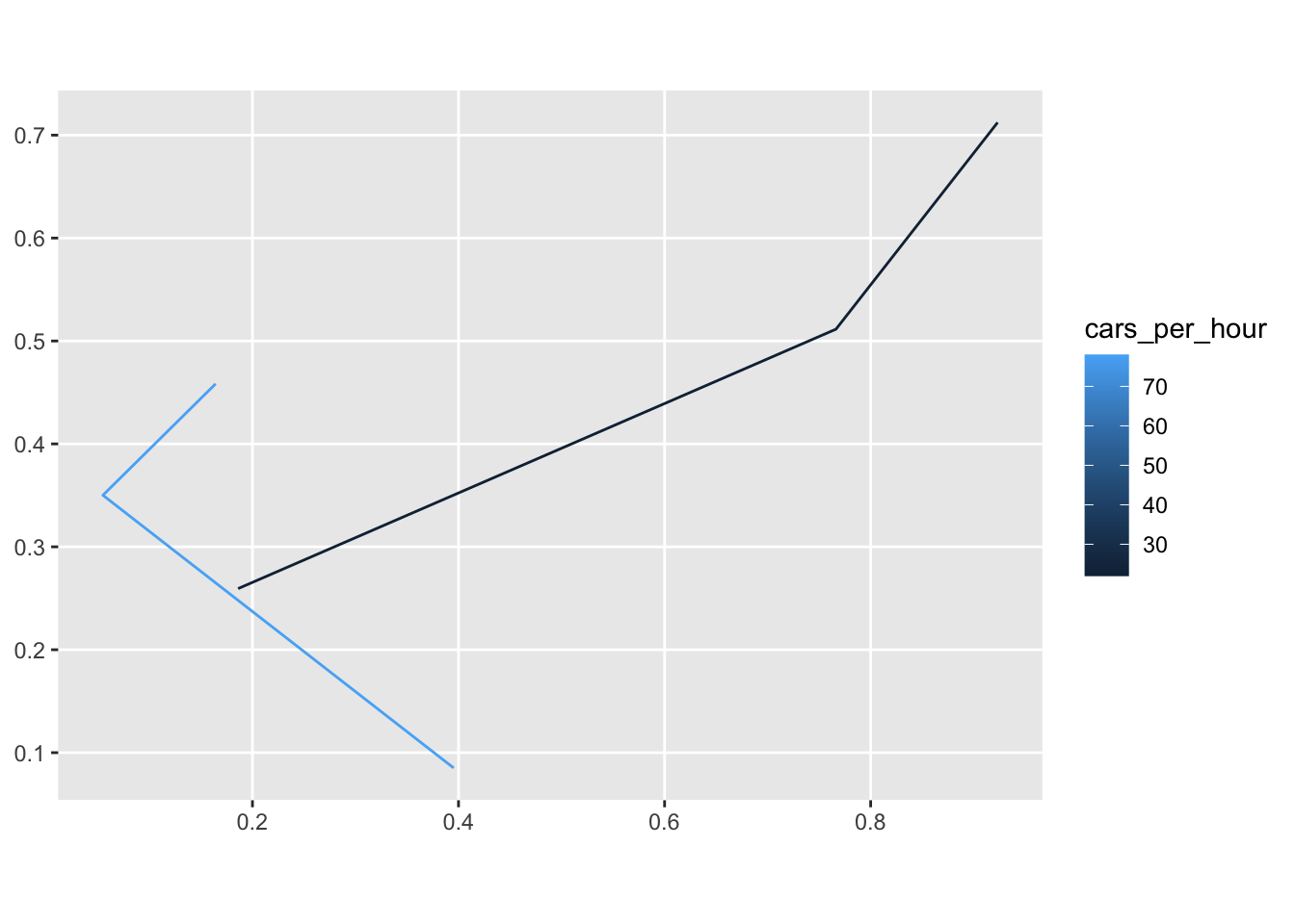
ggplot(lnstr_sf) + 
  geom_sf(aes(color = cars_per_hour))

Useful methods in sf:

Code
methods(class = "sf")
  [1] [                            [[<-                        
  [3] [<-                          $<-                         
  [5] aggregate                    anti_join                   
  [7] arrange                      as.data.frame               
  [9] cbind                        coerce                      
 [11] dbDataType                   dbWriteTable                
 [13] distinct                     dplyr_reconstruct           
 [15] drop_na                      duplicated                  
 [17] filter                       full_join                   
 [19] gather                       group_by                    
 [21] group_split                  identify                    
 [23] initialize                   inner_join                  
 [25] left_join                    merge                       
 [27] mutate                       nest                        
 [29] pivot_longer                 pivot_wider                 
 [31] plot                         points                      
 [33] print                        rbind                       
 [35] rename_with                  rename                      
 [37] right_join                   rowwise                     
 [39] sample_frac                  sample_n                    
 [41] select                       semi_join                   
 [43] separate_rows                separate                    
 [45] show                         slice                       
 [47] slotsFromS3                  spread                      
 [49] st_agr                       st_agr<-                    
 [51] st_area                      st_as_s2                    
 [53] st_as_sf                     st_as_sfc                   
 [55] st_bbox                      st_boundary                 
 [57] st_break_antimeridian        st_buffer                   
 [59] st_cast                      st_centroid                 
 [61] st_collection_extract        st_concave_hull             
 [63] st_convex_hull               st_coordinates              
 [65] st_crop                      st_crs                      
 [67] st_crs<-                     st_difference               
 [69] st_drop_geometry             st_exterior_ring            
 [71] st_filter                    st_geometry                 
 [73] st_geometry<-                st_inscribed_circle         
 [75] st_interpolate_aw            st_intersection             
 [77] st_intersects                st_is_full                  
 [79] st_is_valid                  st_is                       
 [81] st_join                      st_line_merge               
 [83] st_m_range                   st_make_valid               
 [85] st_minimum_bounding_circle   st_minimum_rotated_rectangle
 [87] st_nearest_points            st_node                     
 [89] st_normalize                 st_point_on_surface         
 [91] st_polygonize                st_precision                
 [93] st_reverse                   st_sample                   
 [95] st_segmentize                st_set_precision            
 [97] st_shift_longitude           st_simplify                 
 [99] st_snap                      st_sym_difference           
[101] st_transform                 st_triangulate_constrained  
[103] st_triangulate               st_union                    
[105] st_voronoi                   st_wrap_dateline            
[107] st_write                     st_z_range                  
[109] st_zm                        summarise                   
[111] text                         transform                   
[113] transmute                    ungroup                     
[115] unite                        unnest                      
see '?methods' for accessing help and source code

9.4 Raster Data

Raster data represent spatial information as a grid of cells (or pixels), where each cell stores a value for a specific variable such as elevation, temperature, or land cover. The cells are arranged in rows and columns, covering a continuous area of space.

Raster data are typically used for continuous phenomena that vary smoothly across space. The spatial resolution depends on the cell size: smaller cells capture finer detail but require more storage.

Common raster formats include GeoTIFF and .grd. In R, raster data are handled by packages such as raster and terra.

  • Raster files, as you might know, have a much more compact data structure than vectors.
  • A raster is defined by:
    • a CRS
    • coordinates of its origin
    • a distance or cell size in each direction
    • a dimension or numbers of cells in each direction
    • an array of cell values
Code
## install.packages("raster")
library(raster)

HARV <- raster("data/HARV_RGB_Ortho.tif")

HARV
class      : RasterLayer 
band       : 1  (of  3  bands)
dimensions : 2317, 3073, 7120141  (nrow, ncol, ncell)
resolution : 0.25, 0.25  (x, y)
extent     : 731998.5, 732766.8, 4712956, 4713536  (xmin, xmax, ymin, ymax)
crs        : +proj=utm +zone=18 +datum=WGS84 +units=m +no_defs 
source     : HARV_RGB_Ortho.tif 
names      : HARV_RGB_Ortho_1 
values     : 0, 255  (min, max)
Code
plot(HARV)

This raster is generated as part of the NEON Harvard Forest field site .

Code
## useful commands

crs(HARV)
Coordinate Reference System:
Deprecated Proj.4 representation:
 +proj=utm +zone=18 +datum=WGS84 +units=m +no_defs 
WKT2 2019 representation:
PROJCRS["unknown",
    BASEGEOGCRS["unknown",
        DATUM["World Geodetic System 1984",
            ELLIPSOID["WGS 84",6378137,298.257223563,
                LENGTHUNIT["metre",1]],
            ID["EPSG",6326]],
        PRIMEM["Greenwich",0,
            ANGLEUNIT["degree",0.0174532925199433],
            ID["EPSG",8901]]],
    CONVERSION["UTM zone 18N",
        METHOD["Transverse Mercator",
            ID["EPSG",9807]],
        PARAMETER["Latitude of natural origin",0,
            ANGLEUNIT["degree",0.0174532925199433],
            ID["EPSG",8801]],
        PARAMETER["Longitude of natural origin",-75,
            ANGLEUNIT["degree",0.0174532925199433],
            ID["EPSG",8802]],
        PARAMETER["Scale factor at natural origin",0.9996,
            SCALEUNIT["unity",1],
            ID["EPSG",8805]],
        PARAMETER["False easting",500000,
            LENGTHUNIT["metre",1],
            ID["EPSG",8806]],
        PARAMETER["False northing",0,
            LENGTHUNIT["metre",1],
            ID["EPSG",8807]],
        ID["EPSG",16018]],
    CS[Cartesian,2],
        AXIS["(E)",east,
            ORDER[1],
            LENGTHUNIT["metre",1,
                ID["EPSG",9001]]],
        AXIS["(N)",north,
            ORDER[2],
            LENGTHUNIT["metre",1,
                ID["EPSG",9001]]]] 
Code
methods(class = class(HARV))
  [1] !                     !=                    [                    
  [4] [[                    [[<-                  [<-                  
  [7] %in%                  ==                    $                    
 [10] $<-                   addLayer              adjacent             
 [13] aggregate             all.equal             area                 
 [16] Arith                 as.array              as.character         
 [19] as.data.frame         as.factor             as.integer           
 [22] as.list               as.logical            as.matrix            
 [25] as.raster             as.vector             asFactor             
 [28] atan2                 bandnr                barplot              
 [31] bbox                  blockSize             boundaries           
 [34] boxplot               brick                 buffer               
 [37] calc                  cellFromRowCol        cellFromRowColCombine
 [40] cellFromXY            cellStats             clamp                
 [43] click                 clump                 coerce               
 [46] colFromCell           colFromX              colSums              
 [49] Compare               contour               coordinates          
 [52] corLocal              couldBeLonLat         cover                
 [55] crop                  crosstab              crs<-                
 [58] cut                   cv                    density              
 [61] dim                   dim<-                 direction            
 [64] disaggregate          distance              extend               
 [67] extent                extract               flip                 
 [70] focal                 freq                  getValues            
 [73] getValuesBlock        getValuesFocal        gridDistance         
 [76] hasValues             head                  hist                 
 [79] image                 init                  initialize           
 [82] inMemory              interpolate           intersect            
 [85] is.factor             is.finite             is.infinite          
 [88] is.na                 is.nan                isLonLat             
 [91] KML                   labels                layerize             
 [94] length                levels                levels<-             
 [97] lines                 localFun              log                  
[100] Logic                 mask                  match                
[103] Math                  Math2                 maxValue             
[106] mean                  merge                 metadata             
[109] minValue              modal                 mosaic               
[112] names                 names<-               ncell                
[115] ncol                  ncol<-                nlayers              
[118] nrow                  nrow<-                origin               
[121] origin<-              overlay               persp                
[124] plot                  predict               print                
[127] proj4string           proj4string<-         quantile             
[130] raster                rasterize             ratify               
[133] readAll               readStart             readStop             
[136] reclassify            rectify               res                  
[139] res<-                 resample              RGB                  
[142] rotate                rowColFromCell        rowFromCell          
[145] rowFromY              rowSums               sampleRandom         
[148] sampleRegular         sampleStratified      scale                
[151] select                setMinMax             setValues            
[154] shift                 show                  spplot               
[157] stack                 stackSelect           stretch              
[160] subs                  subset                Summary              
[163] summary               t                     tail                 
[166] terrain               text                  trim                 
[169] unique                update                values               
[172] values<-              Which                 which.max            
[175] which.min             wkt                   writeRaster          
[178] writeStart            writeStop             writeValues          
[181] xFromCell             xFromCol              xmax                 
[184] xmax<-                xmin                  xmin<-               
[187] xres                  xyFromCell            yFromCell            
[190] yFromRow              ymax                  ymax<-               
[193] ymin                  ymin<-                yres                 
[196] zonal                 zoom                 
see '?methods' for accessing help and source code

9.5 Maps

  • We are going to create a few different types of maps, which will require different R packages.

    • Static Maps

      • Most common type of visual output

        • plot() most commonly used command from base are

        • Can utilize ggplot() and tmap()

    • Animated Maps

      • Are becoming more widely used than in the past

        • We will make these with tmap()
    • Interactive Maps

      • While static and animated maps can enliven geographic datasets, interactive maps can take them to a new level

        • leaflet()

9.5.1 Plotting Simple Features (sf)

  • As we have already briefly seen, the sf package extends the base plot command, so it can be used on sf objects.
  • We are going to create a choropleth map with sf
Code
library(sf)

philly_crimes_sf <- st_read("data/PhillyCrimerate.shp")
Reading layer `PhillyCrimerate' from data source 
  `/Users/junyan/work/teaching/1010-f25/1010f25/data/PhillyCrimerate.shp' 
  using driver `ESRI Shapefile'
Simple feature collection with 384 features and 4 fields
Geometry type: MULTIPOLYGON
Dimension:     XY
Bounding box:  xmin: 1739497 ymin: 457343.7 xmax: 1764030 ymax: 490544.9
Projected CRS: Albers
Code
glimpse(philly_crimes_sf)
Rows: 384
Columns: 5
$ GEOID10    <chr> "42101000100", "42101000200", "42101000300", "42101000401",…
$ n_homic    <int> 10, 4, 7, 9, 6, 9, 1, 3, 1, 1, 1, 2, 1, 1, 4, 1, 1, 1, 3, 2…
$ tract_area <dbl> 704688.5, 381197.4, 550949.2, 231327.5, 303868.9, 427352.7,…
$ homic_rate <dbl> 14.190667, 10.493252, 12.705346, 38.905882, 19.745355, 21.0…
$ geometry   <MULTIPOLYGON [m]> MULTIPOLYGON (((1752148 467..., MULTIPOLYGON (…
Code
plot(philly_crimes_sf)

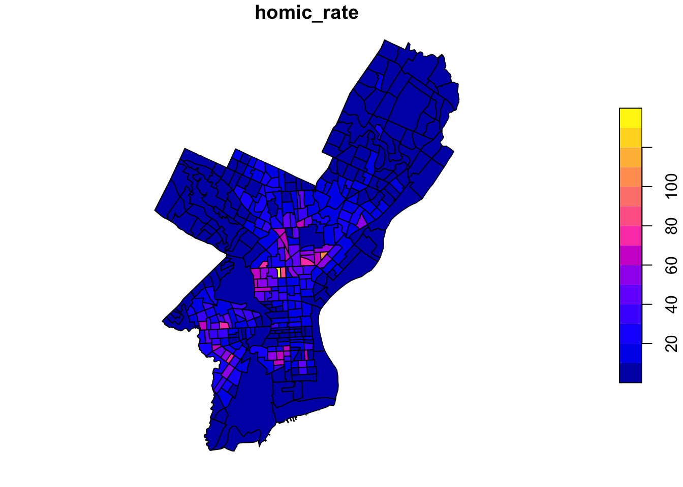
Notice that the plot function will try and provide a map of every variable in the data set.

To plot a single attribute, we need to provide an object of class sf.

Code
plot(philly_crimes_sf$homic_rate) # this is a numeric vector!

Code
plot(philly_crimes_sf["homic_rate"])

Based on the plot above, it would seem that we have a lot of “empty” geographic units or unevenly distributed

Code
ggplot(philly_crimes_sf) +
  geom_histogram(mapping = aes(x = homic_rate))

Let’s break the plot up into quantiles to better distinguish the census tracts with low values.

Code
plot(philly_crimes_sf["homic_rate"], 
     main = "Philadelphia homicide density per square km", 
     breaks = "quantile")

9.5.2 Mapping with ggplot()

Package ggplot is a widely used and powerful plotting library for R as we have utilized over the course of the semester. It is not specifically geared towards mapping, but one can generate great maps.

Code
ggplot(philly_crimes_sf) + 
  geom_sf(aes(fill=homic_rate))

Homicide rate is a continuous variable and is plotted by ggplot as such. If we wanted to plot our map as a ‘true’ choropleth map we need to convert our continuous variable into a categorical one, according to whichever brackets we want to use.

Code
breaks_qt <- classInt::classIntervals(
                           c(min(philly_crimes_sf$homic_rate) - .00001,
                             philly_crimes_sf$homic_rate),
                           n = 7, style = "quantile")

philly_crimes_sf <- mutate(philly_crimes_sf,
                           homic_rate_cat = cut(homic_rate, breaks_qt$brks)) 

ggplot(philly_crimes_sf) + 
    geom_sf(aes(fill=homic_rate_cat)) +
    scale_fill_brewer(palette = "OrRd") 

9.5.3 Mapping with tmap()

Package tmap is based on the idea of a ‘grammar of graphics’ similar to ggplot This involves a separation between the input data and the aesthetics (how data are visualized): each input dataset can be ‘mapped’ in a range of different ways including location on the map (defined by data’s geometry), color, and other visual variables. The package is specifically designed to make creation of thematic maps more convenient with ggplot syntax.

  • tm_shape() defines the data, raster, and vector objects.

  • tm_polygons() sets the attribute variable to map, the break style, and a title.

  • tm_fill() & tm_borders() control the layers.

Code
library(tmap)

m <- tm_shape(philly_crimes_sf) +
    tm_polygons(
        "homic_rate",
        fill.scale = tm_scale_intervals(style = "quantile", n = 4),
        fill.legend = tm_legend("Philadelphia \nhomicide density \nper sqKm")
    )

m

Package tmap has a nice feature that allows us to give basic interactivity to the map. We can switch from plot mode into view mode and call the plot.

Code
tmap_mode("view")

m

Layers can be controlled by tm_fill() & tm_borders().

Code
#
#install.packages("spData")
library(spData)
library(tmap)

# Add fill layer to nz shape
tm_shape(nz) +
  tm_fill() 
Code
# Add border layer to nz shape
tm_shape(nz) +
  tm_borders() 
Code
# Add fill and border layers to nz shape
tm_shape(nz) +
  tm_fill() +
  tm_borders() 

A useful feature of tmap is its ability to store objects representing maps

Code
map_nz = tm_shape(nz) + tm_polygons()

class(map_nz)
[1] "tmap"
  • This allows you to plot your maps later and/or add additional layers
Code
map_nz1 <- map_nz + 
    tm_polygons("Population",  fill.scale = tm_scale_intervals(),
                palette = "viridis", 
                title = "Population (by region)") +
    tm_layout(frame = FALSE)

map_nz1

There are no limits to the number of layers or shapes that can be added to tmap objects. Additionally, tmap allows multiple map objects to be arranged in a single plot with tmap_arrange()

Code
map_nz2 <- tm_shape(nz) +
  tm_polygons("Median_income", style = "pretty", palette = "brewer.blues",
              title = "Median income")

# combined
tmap_arrange(map_nz1, map_nz2) #, map_nz3)

9.5.3.1 Animation with Package gifski

Consider the United Nations urban populaton data including projections. Package tmap makes it easy to create maps with year as facet.

urb_1970_2030 <- urban_agglomerations |>
  filter(year == 1970| year == 1990 | year == 2010 | year == 2030) 


tm_shape(world) +
  tm_polygons() +
  tm_shape(urb_1970_2030) +
  tm_symbols(col = "black", border.col = "white", size = "population_millions") +
  tm_facets(by = "year", nrow = 2, free.coords = FALSE)


urb_anim = tm_shape(world) + tm_polygons() + 
  tm_shape(urban_agglomerations) + tm_dots(size = "population_millions") +
  tm_facets(along = "year", free.coords = FALSE)

Package gifski takes the urb_anim object and create a GIF image, in which each year is a frame.

library(gifski)

tmap_animation(urb_anim, filename = "urb_anim.gif", delay = 25)

9.5.4 Mapping with leaflet()

Package leaflet provides bindings to the Leaflet JavaScript library, “the leading open-source JavaScript library for mobile-friendly interactive maps.” We have already seen a simple use of leaflet in the tmap example.

Let’s build up the map step by step

Code
library(leaflet) 

# reproject
philly_WGS84 <- st_transform(philly_crimes_sf, 4326)

leaflet(philly_WGS84) %>%
  addPolygons()

To map the homicide density we use addPolygons()

Code
pal_fun <- colorQuantile("YlOrRd", NULL, n = 5)

p_popup <- paste0("<strong>Homicide Density: </strong>", philly_WGS84$homic_rate)

m <- leaflet(philly_WGS84) %>%
    addPolygons(
        stroke = FALSE, # remove polygon borders
        fillColor = ~pal_fun(homic_rate), # set fill color with function from above and value
        fillOpacity = 0.8, smoothFactor = 0.5, # make it nicer
        popup = p_popup)  # add popup

m

We can add a basemap, which defaults to OSM, with addTiles()

Code
m <- addTiles(m)
m

Lastly, we add a legend with addLegend()

Code
m <-  addLegend(m,
                "bottomright",  # location
                pal=pal_fun,    # palette function
                values=~homic_rate,  # value to be passed to palette function
                title = 'Philadelphia homicide density per sqkm') # legend title

m